The current maps and descriptions have been updated for the 2026 routes. These are expected to be final, but should any further amendments be required for safety or other reasons then this will be updated well before the race.
The start/finish area has been moved from the Riverside Park to SMK Tun Fuad Stephens due to ongoing construction works for a road bridge. The SMK Tun Fuad Stephens is close to the Dewan which is used for registration, bag drop and half-way station for the 100 km. Outlines of the 2026 routes and elevation profiles are provided below together with course details. Any further updates and more detailed route descriptions will be provided to all competitors prior to the race.
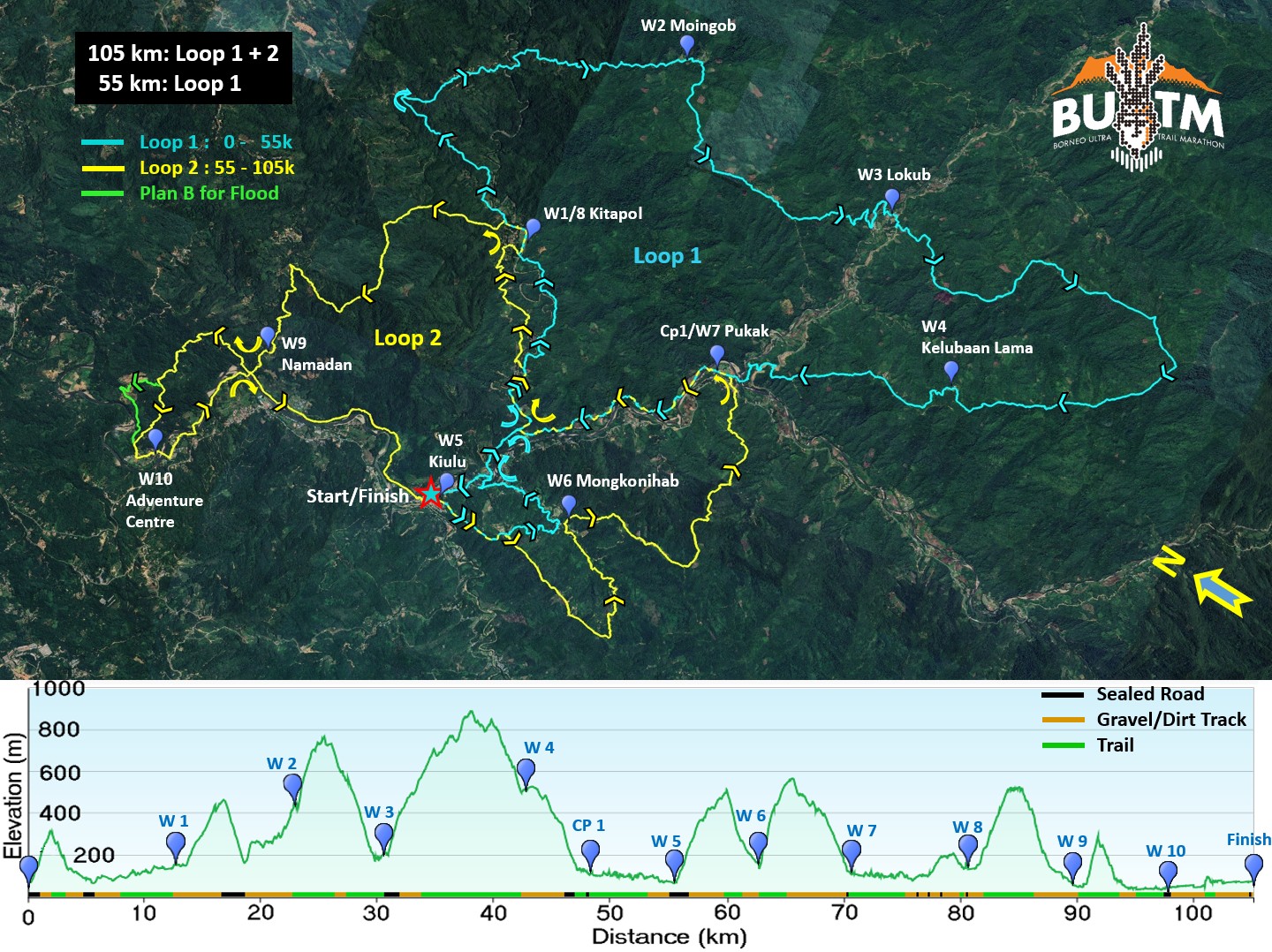
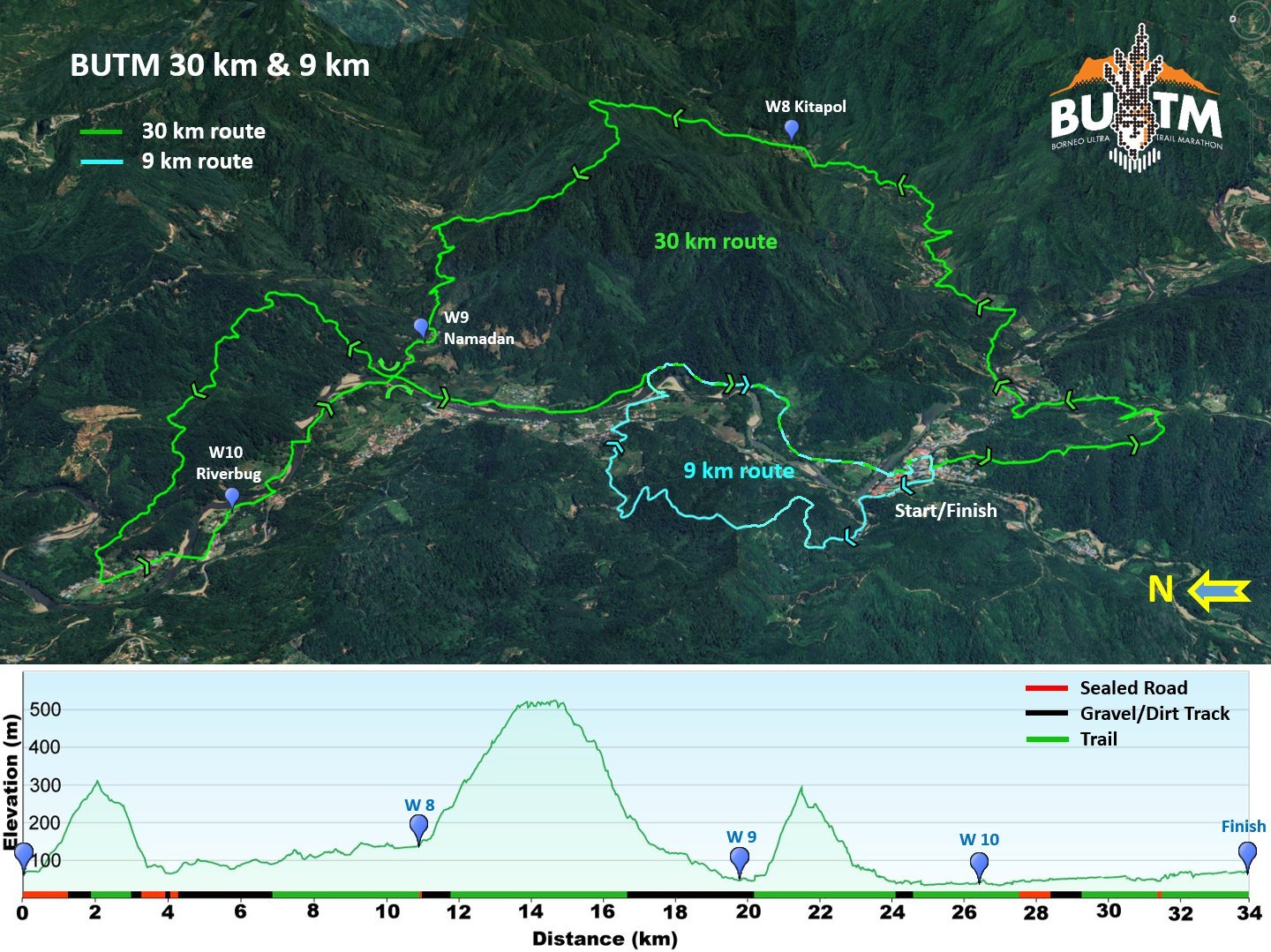
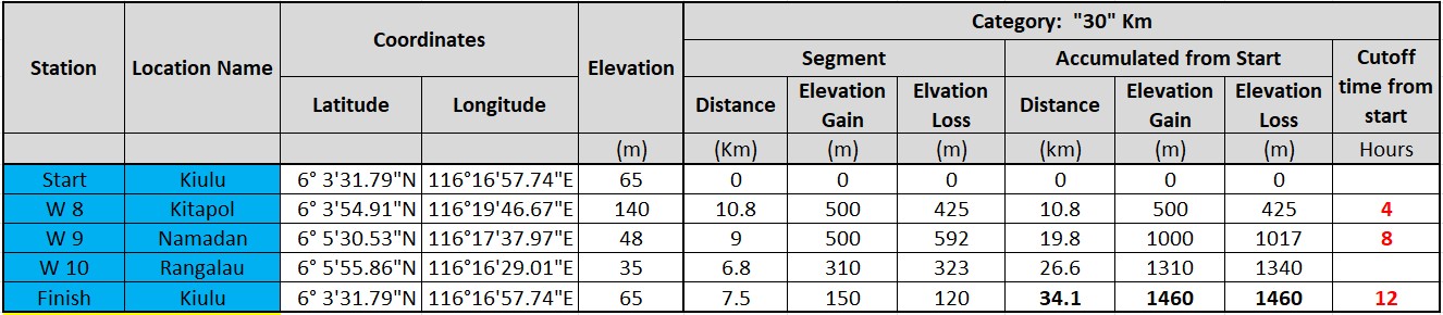
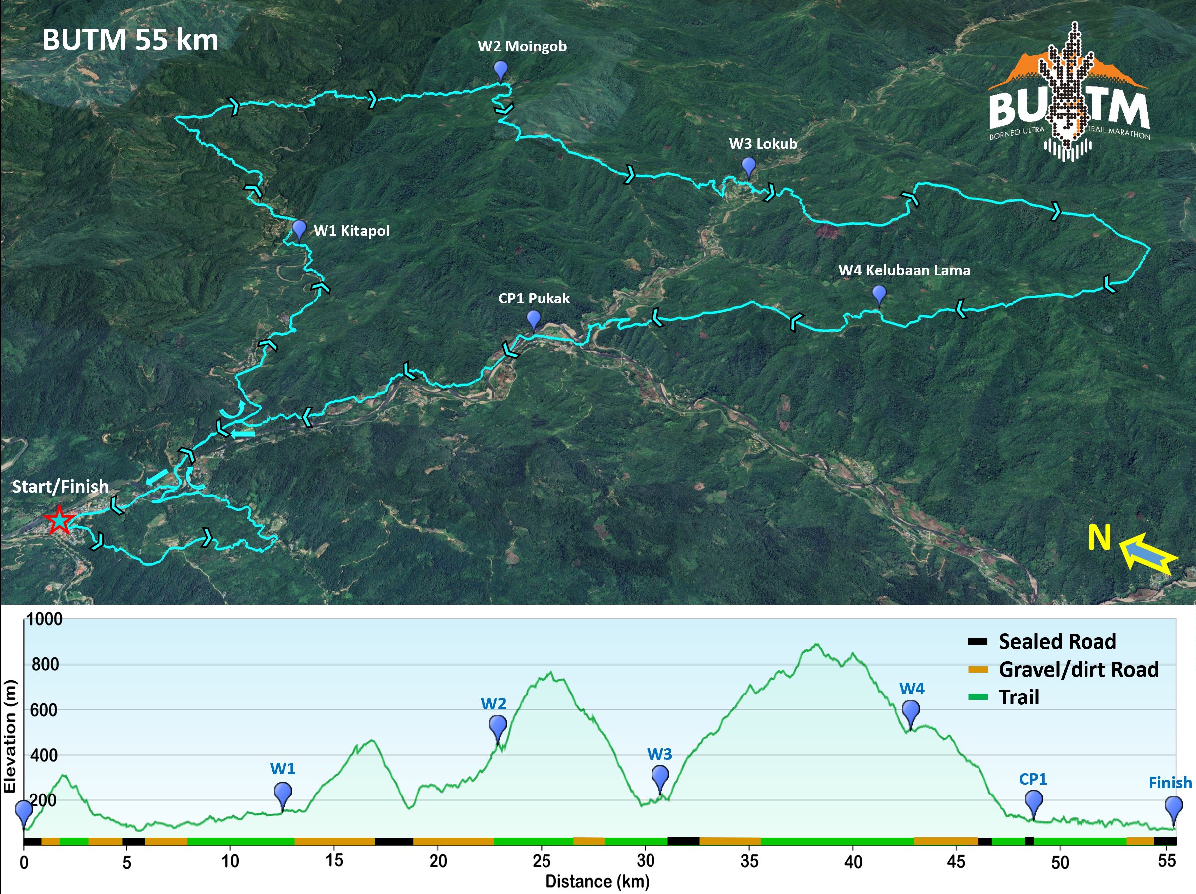
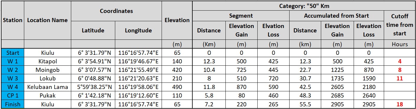
The Water (Aid) stations are numbered W1 to W10 based on the 100 km course. The 30k course will skip W1 to W7 and go to W8 from the start. The 50 km course will follow the 100k route through W1 to W4, then CP1 and to the finish line (first half of 100 km course) - please refer to the course maps below.
The 2026 routes are ITRA rated with 5 points for the 100k, 3 points for the 50k and 2 points for the 30k route and the 3 courses are part of the ITRA National League Championship. The 100 km and 50 km routes are qualifiers for the Asia Trail Master Championship, and the 100 km course will also be a qualifying race for the Western States 100-mile Endurance Race in 2027. Refer to General Information for details.
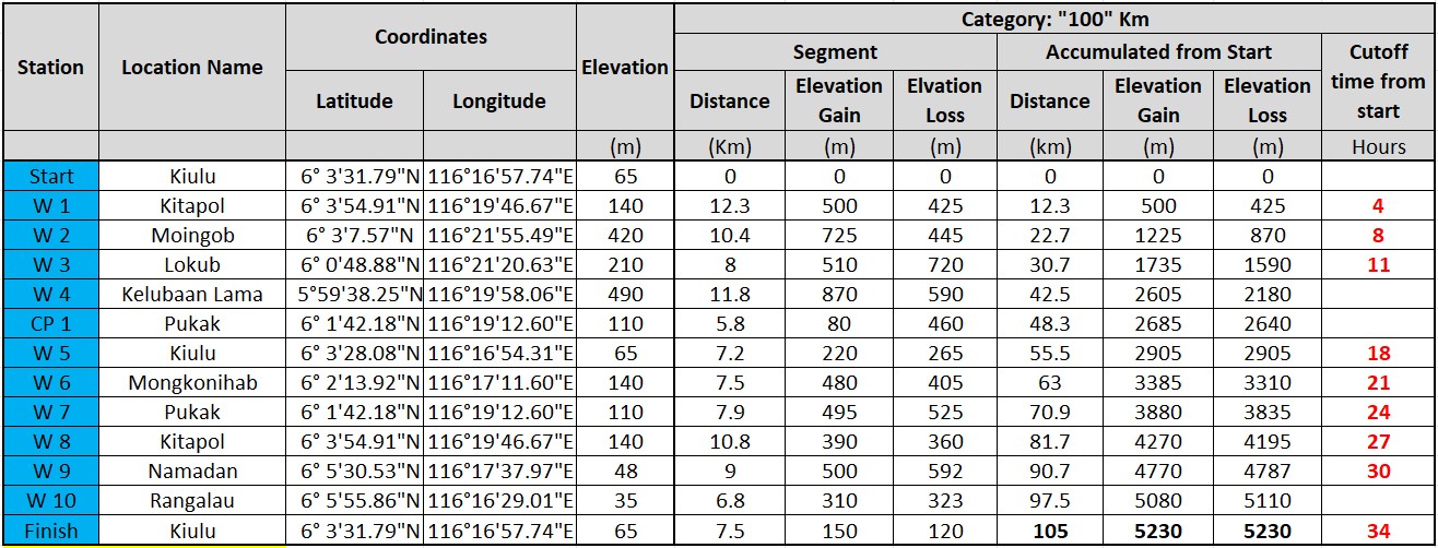
You may note that the accumulated elevation gains in the ITRA ratings are lower than in the course details below. This is due to a filtering process performed by ITRA where they filter out smaller undulations in the GPS elevation record which could be caused by inaccuracies in the measurements. We have kept the data from the original GPS tracks in our course data as we know that many parts of the flatter looking sections have these small but steep ups and downs which can absolutely be felt when you are out on the course, but which are filtered out by the ITRA data filtering process. The experience from many wrist GPS watches is that they will show slightly longer distances and sometimes higher elevation gains than our records with the larger hand-held GPS.
NOTE The distances and elevation gains/losses provided are measured with a Garmin GPS64. You may find that you get different data if you are carrying a gps or other device to measure distances and elevations during the race. You will most likely record longer distances. This is due to a combination of inaccuracies in the GPS recording through for instance loss of signal under forest canopies, additional distance travelled around aid stations etc as well as a loss of distance when the course is filtered by being represented by linear segments between GPS points. Wrist-type gps devices may also not achieve as good reception and be as reliable as the larger GPS units.
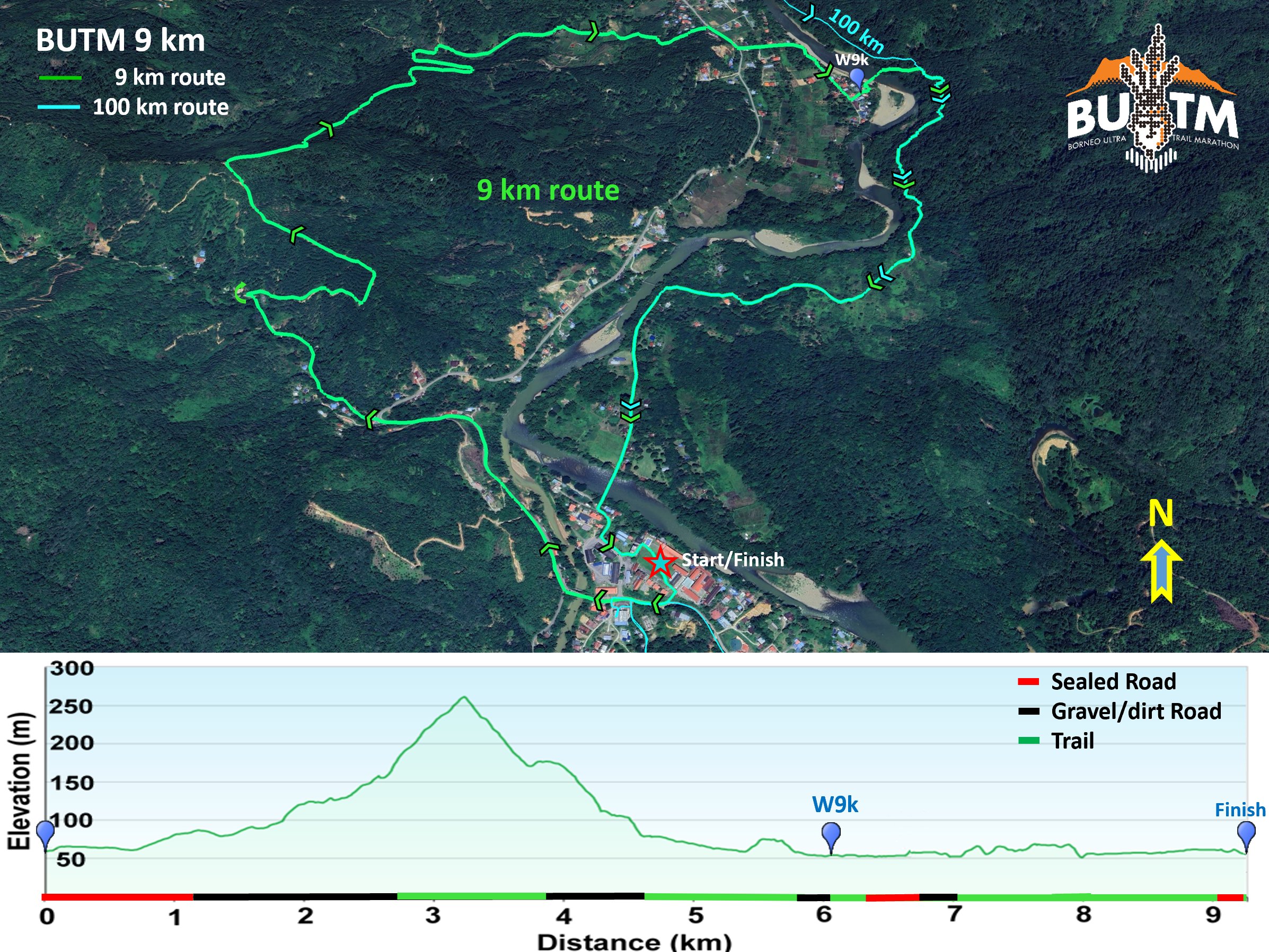
9 km Route
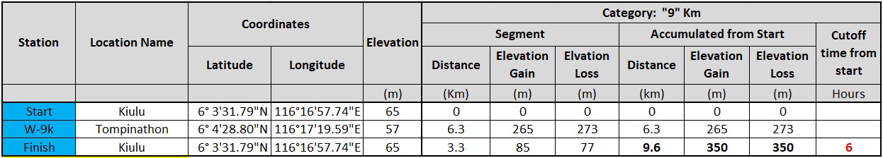
The "Short Course" is intended as a non-competitive "family-oriented" run with a good opportunity to introduce the next generation to trail running. The current course is 9.6 km, which by some is considered too long for kids, but we have in past races often seen the parents struggle more than the kids - give them a chance and you may be surprised. The current 9 km route starts at Kiulu and follows the main road for just under 1 km before turning off onto a gravel road. A gradual climb on the gravel road is followed by a steeper climb on a dirt track up a hillside to the ridgeline which is followed. A right turn leads to a descent through mixed forest and rubber plantations to a stream crossing to reach a smaller trail that leads to a larger river crossing. This has a hanging bridge, but it is not suitable for a larger number of people and will only be used for emergency. Should the rivers be too high to cross safely, competitors will be redirected to an alternative route to avoid the river crossings. After the second river crossing, the route follows small trails alongside padi fields and through a rubber plantation to reach the main sealed road. This is followed for a short distance before turning off towards W9k at Tomphinaton. Immediately after the water station you cross a hanging bridge across the main river to join the 100 k course on a new dirt road under construction, potentially slippery in wet conditions. Continue through a mixture of forest, pineapple/rubber plantations to emerge at a concrete pedestrian path leading to the hanging bridge across the river. Cross this and follow markers through town to the finish line at the school field.
30 km Route
The 30 km route starts straight into one of three major hills on the 30 km course - see profile below. The first stretch is on concrete road followed by a gravel road that has plenty of space for overtaking to allow participants to sort themselves out in terms of speed. After a 250 m climb, 30k runners will turn left at the Hawun Valley Campsite and Cafe. You may take a moment to enjoy the often-stunning morning views over the river valley and to Mt. Kinabalu from the platform at the campsite. A dirt track / trail leads back down to the river valley to cross the main river on a newly completed road bridge (to avoid any queues forming at hanging bridges).
After crossing the main river, it is 3 km on undulating dirt road, following the river to Mantaranau much of the way. This is a fast section for those who prefer the more open gravel and dirt tracks. From Mantaranau it is a new route introduced in 2025, starting with a kilometer on dirt track then 3 km on small trails through forest, crossing numerous smaller streams to reach W8 at Kitapol. The trail is narrow but generally good with shade and plenty of opportunities to cool off in the small streams. These can generally be crossed without getting wet shoes except in very wet conditions. W8 is in a new hall along the main river - this also provides a good opportunity for a refreshing dip before the next hill which is the main climb on the 30 km route.
From W8 the course climbs steeply for 400m elevation gain, initially on a dirt track, then going into trails through forest and bamboo to follow an undulating ridgeline through bamboo forest before descending on trails through mixed forest, bamboo and rubber plantations to reach a dirt road. This joins a larger gravel/dirt track at the bottom of the 400 m descent. The undulating gravel/dirt track descends further over 2.5 km to W9 at Namadan.
From W9 the course continues for a short distance on the dirt track, then crosses a suspension bridge for a steep 250m climb through forest to reach a deteriorated road. The road is followed a short distance downhill, then taking a trail with caution past an older landslide and continuing downhill through forest, initially on open trails that gradually turn into a smaller trail that crosses a stream numerous times. Under "normal" conditions the stream crossings can generally be carried out with care without getting wet shoes, but as experienced in 2025 the stream can come up significantly in very wet conditions. All crossings have rope to aid, and if the weather should be too wet, a "Plan B" route will be put into effect which climes a small hill to bypass most of the stream crossings. The course then joins a gravel road that passes through Rangalau Lama, crosses a hanging bridge and follows a trail to W10 at The Adventure Centre along the Kiulu River.
From W10 the course follows the main Kiulu river valley upriver on variable road, track and trails to the finish line at Kiulu.
"50" km Route
The 2026 50k route follows the first (blue) loop of the 100 km route - see further below under 100k description. The "50k" (and 100k) route initially follows the same route as the 30k but continues for another short distance past the Hawun Valley Campsite to turn left and descend a rough track down to the bottom of the valley. The gravel/dirt road at the bottom of the valley is followed to the main sealed road, then crossing the river on a road bridge (to avoid queue formation on hanging bridges).
The course follows the same route as the 30k to W8. Initially it is 3 km on undulating dirt road, following the river to Mantaranau much of the way. This is a fast section for those who prefer the more open gravel and dirt tracks. From Mantaranau it is a new route introduced in 2025, starting with a kilometer on undulating dirt track to a chilly plantation, then 3 km on small trails through forest, crossing numerous small streams to reach W8 at Kitapol. The trail is narrow but generally good with shade and plenty of opportunities to cool off in the small streams. These can generally be crossed without getting wet shoes except in very wet conditions. W8 is in a new hall along the main river - this also provides a good opportunity for a refreshing dip before the next hill which is hot and exposed on a sunny day.
After W1, the 50k/100 k climbs 400m over 4 km on gravel, then drops 300m over a 1 km mostly sealed road to reach a major river crossing. This may be crossed via a hanging bridge or via a ford that gives a good opportunity for a refreshing dip in the river. From the river crossing, it is an initial steep uphill, then 3 km on a gradually climbing gravel/dirt track to reach W2 at Moingob.
From W2, it is 2.5 km with 400 m elevation gain on a small trail through forest, crossing two larger and a couple of smaller streams to reach the top of the ridge at the "shoulder" of Bukit Tikolod. From here there are excellent views on a clear day to W1 at Kitapol with the ocean further in the background and looking forward to the river valley with W3 and the large horseshoe shaped ridgeline leading to W4 - take a moment to enjoy! The course now follows the ridgeline downwards to a newly cut dirt track which leads to the picturesque Sinansag Village where there will often be refreshments for sale - please bring small change to support the villages along the route if you want to take advantage of what's on offer. From the top is is about 4 km and 600m descent on mixed trail and dirt road to reach W3 at Lokub.
From W3 it is the largest hill on the 50k/100k courses with 12 km, close to 900m ascent and 600m descent to reach W4 at Kelubaan Lama. It starts with 700m of sealed road followed by gravel road that deteriorates into a track and eventually a trail section to reach W4. Views from along the ridgeline are spectacular on a clear day. From W4, it is a quick downhill on a mix of dirt and sealed road to reach the river at the bottom, then a short trail section to reach CP1/W7 at Pukak. From CP1/W7 the course follows the river valley downstream on a mix of trails, dirt tracks and a bit of sealed road to reach the halfway station of W5 back at the hall at Kiulu for the 100 k and the Finish Line at the school for the 50 k category.
100 km Route
The "100k" route resembles a figure 8 with the start/finish and halfway station (W5) centered in the middle, see figure below. The blue loop with the largest hills and the most technical section on the course will be completed first to ensure daylight on the technical sections. This is the same as the 50k course. Competitors then return to the start/finish area, which also works as half-way station with access to the competitor's half-way drop-bag and provision of the main halfway meal. This will be followed by the yellow loop. The first loop has the largest hills and is considered the harder part of the course on the section between W2 and CP1.
The first loop of the "100k" course follows the same course as the 50 k course - please refer to description above.
From W5, the 100 km route starts up the same hill experienced from the start in the morning, but continues past the turnoff to continue up the ridgeline for another 2.5 km and 250m elevation, then followed by a descent to W6 on a mix of dirt track and trail. From W6 it is another another 400 m climb, initially on trails through forest and rubber plantations to reach a rough dirt track at the top of the ridge. This initially continues climbing, then turns down another ridgeline for a long gradual descent to reach W7 at the main river at Pukak.
From W7 the course follows the trails downriver towards Kiulu before turning towards W1/W8 at Kitapol, this time following the dirt track most of the way. After W8 the 100k course follows the same course as the 30 k course, starting with a steep climb for 400m elevation gain, initially on a washed-out dirt track, then going into trails through forest and bamboo to follow an undulating ridgeline. Where the canopy opens up, there are excellent views towards the river valley and ridges with Mt. Kinabalu further in the background on a clear day. From the ridgeline, it is a 2 km descent on trails through mixed forest, bamboo and rubber plantations to reach a dirt road that joins a larger gravel/dirt track at the bottom of the 400 m descent. The undulating gravel/dirt track descends further over 2.5 km to W9 at Namadan.
From W9 the course continues for a short distance on the dirt track, then crosses a suspension bridge for a steep 250m climb through forest to reach a deteriorated road. The road is followed a short distance downhill, then taking a trail past an old landslide area and continuing downhill through forest, initially on open trails that gradually turn to a smaller trail that crosses a stream numerous times. These stream crossings can generally be done without getting wet shoes during dry conditions. The course then joins a gravel road that passes through Rangalau, crosses a hanging bridge and follows a trail to W10 at The Adventure Centre along the Kiulu River. If the conditions should prove very wet similar to 2025, a "Plan B" route will be used to avoid most of the stream crossings if deemed necessary for safety reasons.
From W10 the course follows the main Kiulu river valley upriver on variable road, track and trails to the finish line at Kiulu.