The TMBT 2024 courses are undergoing checking and there may be updates prior to the race. The GPX files included for download in the TMBT Dropbox are based on the 2023 route, but will be amended if there are further updates to the course.
The overall course structure will remain similar, which includes the TMBT "iconic" trail sections such as the Pineapple Ridge, Bukit Dallas and the Vegetable Patch. Two updates that we are expecting include:
- We will maintain or further improve on the updates introduced in 2023 to the 100k, 50k, 30k and 12k routes between W1 and W2 to minimise risks of congestion and waiting time at crossing of hanging bridges.
- A further extension of the new trail section introduced for the 100 km course in 2022 between WS4 and WS5 with the intent to cut out or minimize the section along the main road between Tamparulli and Kundasang.
- There may be optimisation of the small trail section for the 100k, 37k and 7k after W6/start to bypass a landslide area.
- The new route introduced for the 100k/37k before W10 is expected to be maintained but final decision on route choice will be taken in the weeks leading up to the race depending on weather and trail conditions.
Latest course profiles and course data is included below.
Brief Course Outline
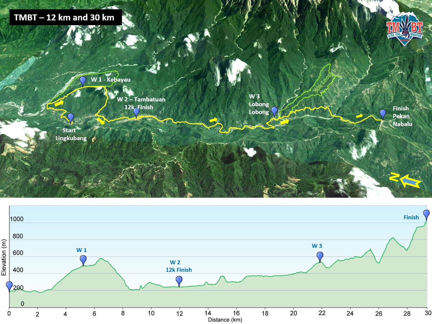
The 12k category will get a taste of a bit of everything with a steep uphill on gravel and sealed road with good views to the rugged western flank of Mt. Kinabalu. This will be followed by a continued climb on trails and dirt road through forest and plantations, before a long downhill section on rough trails to pass through the small village of Bundu Paka. This is followed by crossings of the Kadamaian river via hanging bridges before a short but steep ascent and descent to cross the Kilumbu River, a tributary to the main river. This is the largest river crossing on the entire course which does not have a bridge. A rope and safety personnel will be on hand to guide the crossing, which may involve anything from ankle to thigh deep water, depending on weather conditions leading up to and during the race. If the river becomes too high for safe crossing, an alternative route to the finish will be put into effect. Safety personnel will guide this. The river crossing will be followed by another small climb and then a gradual descent to follow the main river alongside beautiful paddy fields to finish at picturesque Tambatuan.
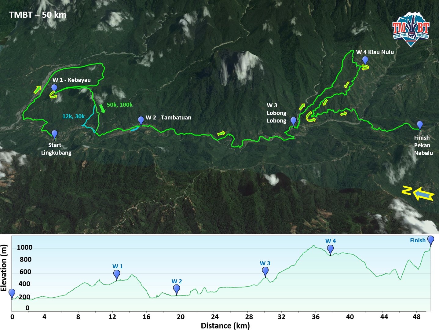
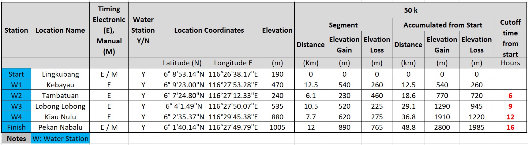
The other race categories continue from Tambatuan through paddy fields before climbing a small ridge and following a narrow trail up over a hill with a stream crossing before dropping steeply down to cross a stream. A short trail section leads to a second larger stream crossing. In wet weather, the flow in the streams can get strong - ropes have been set up and safety personnel may be on hand in case of heavy rain. The stream crossings offer opportunities to cool off on a hot day with the trail continuing up over a small but steep hill, through a combination of forest, fields and plantations, eventually emerging on a track that leads upriver in the valley to cross the main river at Kg. Kaung. This if followed by gravel and sealed road to climb to W3 at the village of Lobong Lobong, nestled on the ridgeline above a river confluence. From Lobong Lobong, a short steep descent will take participants back down across the river. Here the 30k category separates from the 50k and 100k categories to follow a gravel road up to Kg. Kiau Bersatu. A steep trail leads down to cross the Kadamain river, followed by a steep double ascent via Bukit Dallas to finish at Pekan Nabalu.
The 50k and 109k turn upriver at the river crossing after Lobong Lobong and soon start the long climb that leads up to the infamous pineapple ridge with spectacular views to the steep southern face of Mt. Kinabalu with tumbling water falls as well as over the surrounding ridges and valleys. Entrepreneurial villages may have carried soft drinks all the way to the top of the ridge and set up shop for the day - so bring some small cash. Most participants would die for a cold, sugary drink at the top of the ridge .... A gradual descent and contouring around the side of the ridges leads to W4 at the village of Kiau Nulu, where the 50k and 109k courses separate.
The 50k course follows another ridgeline back downwards to emerge on the gravel road to Kiau Bersatu where they will rejoin the 30k course to the initial descent and then steep ascent via the infamous Bukit Dallas to finish at the viewpoint at Pekan Nabalu from where a good portion of the race course can be seen in clear conditions.
The 109k course follows a combination of trails and road down to the bottom of the valley, then follows a gravel/dirt road upriver before crossing the river on a bamboo bridge. A trail section continues upriver to a second bamboo bridge crossing (you may walk through the river to cool off if the water level is not high) before the trail eventually leads into the forest and starts a steep ascent of the ridge to W5 500m above. From W5, a combination of sealed roads, gravel roads and trails lead to the half-way point at the Mount Kinabalu Heritage Resort and Spa (formerly Perkasa) on the top of a hill overlooking Kundasang. The second part of the 100k course brings competitors via a combination of trails and rough roads up to the vegetable farming areas at Mesilau. The "vegetable patch", infamous for potential muddy and slippery trails and tracks, leads to the highest point of the course up close to the eastern ridge of Mt. Kinabalu. From there, a long gradual descent over a combination of dirt tracks, sealed road and trails lead to the last river crossing before the last 800m climb to the finish line back at Mount Kinabalu Heritage Resort and Spa.
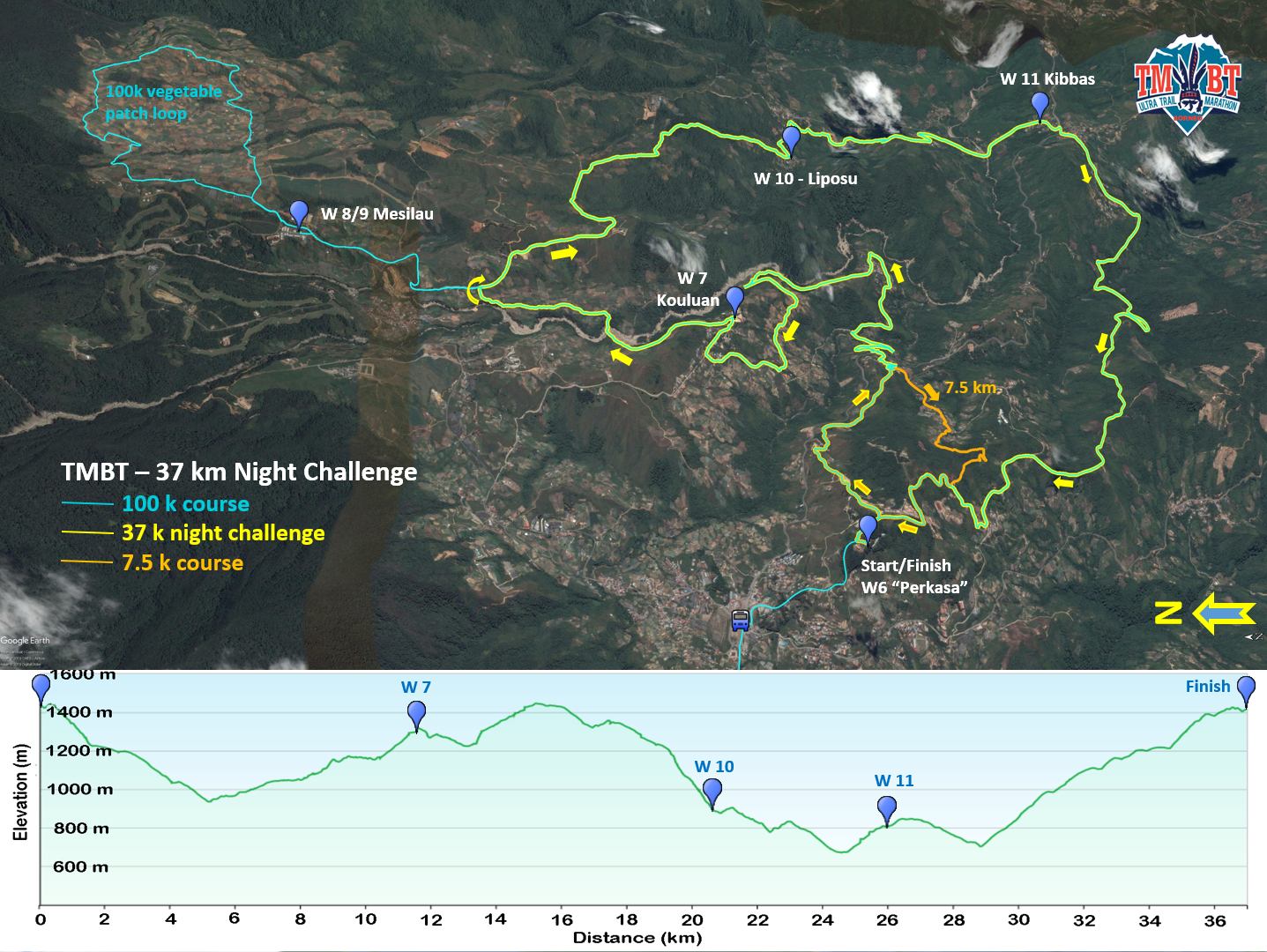
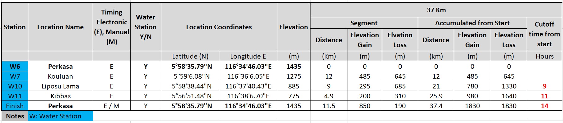
The 37 km Night Challenge first introduced for 2019 is further gaining in popularity and maintained. Perhaps due to the cooler conditions at night, it enjoys the highest finisher rate after the 7.5km course. The night run starts Saturday night at midnight at "Perkasa" - the halfway and finish station for the 109k race category. The race course follows part of the second half of the 109 km course to make a loop via W7, W10 and W11 back to the finish line at Perkasa. Most runners will finish in the early morning so should get to experience sunrise on the trail.
"100k" Course
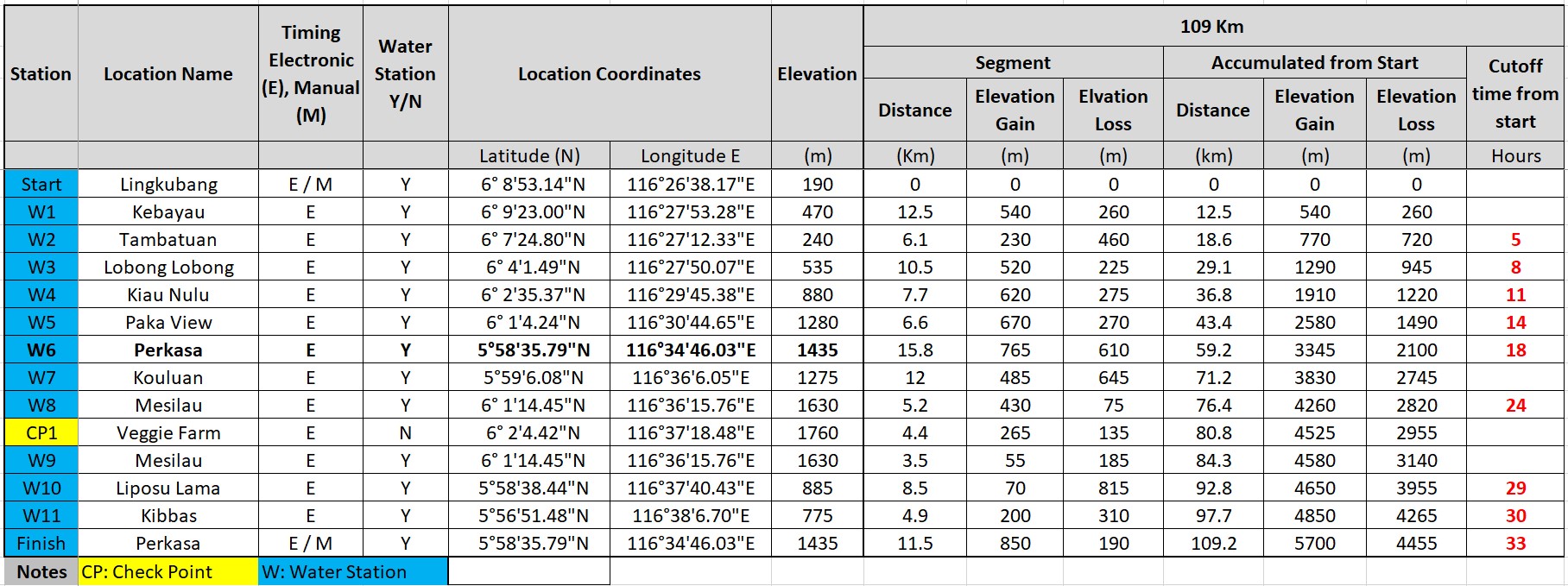
The actual distance with the changes introduced is about 109 km.
50k Course
37k Night Challenge
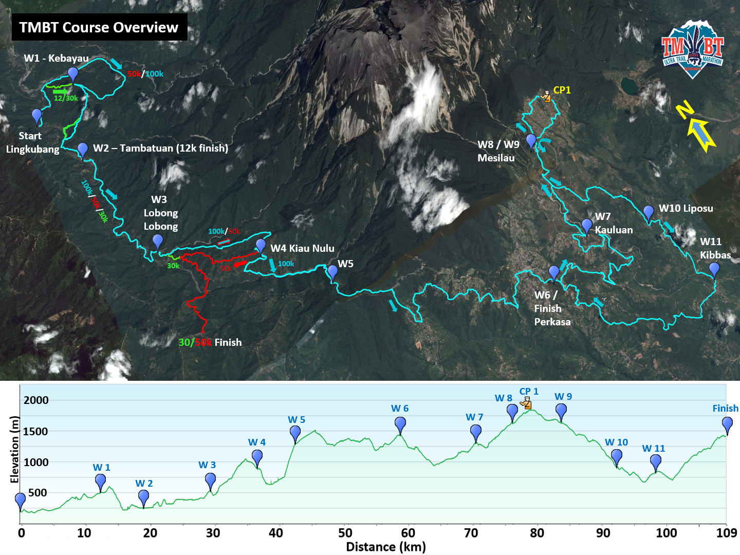
The yellow-green course outlines the 37 km Night Challenge with start and finish at the W6/Finish line of the 109k race at Perkasa. The additional 109k loop and the "shortcut" of the 7.5 km course are also shown.
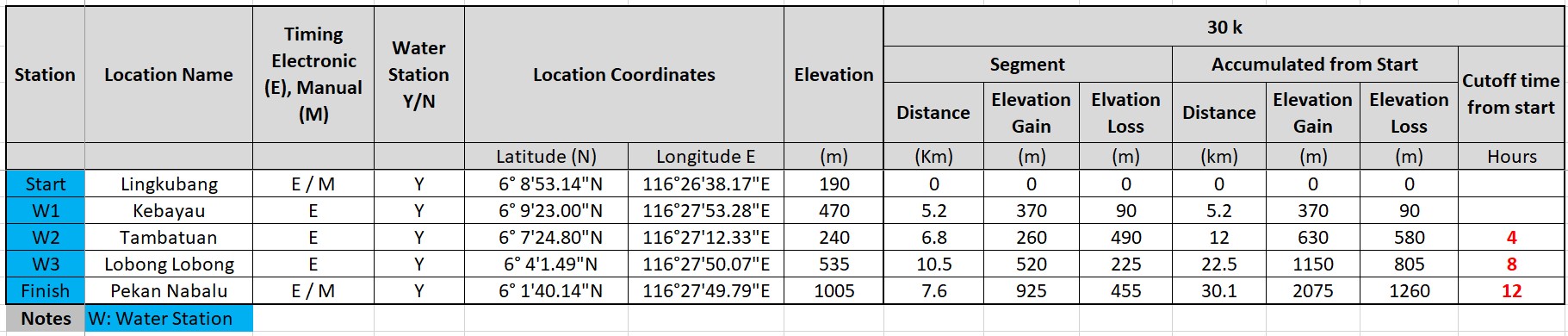
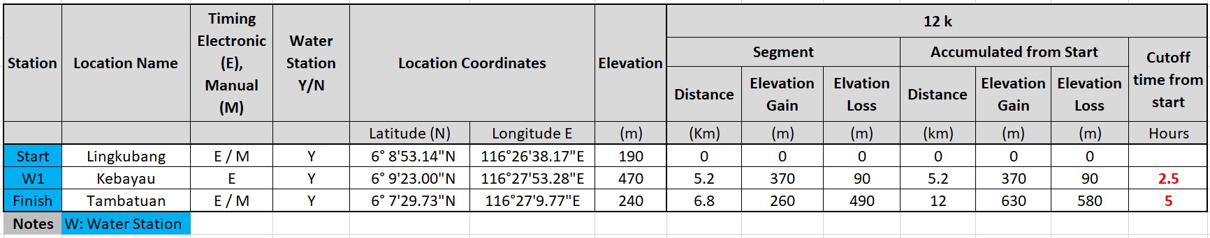
30k & 12k Courses
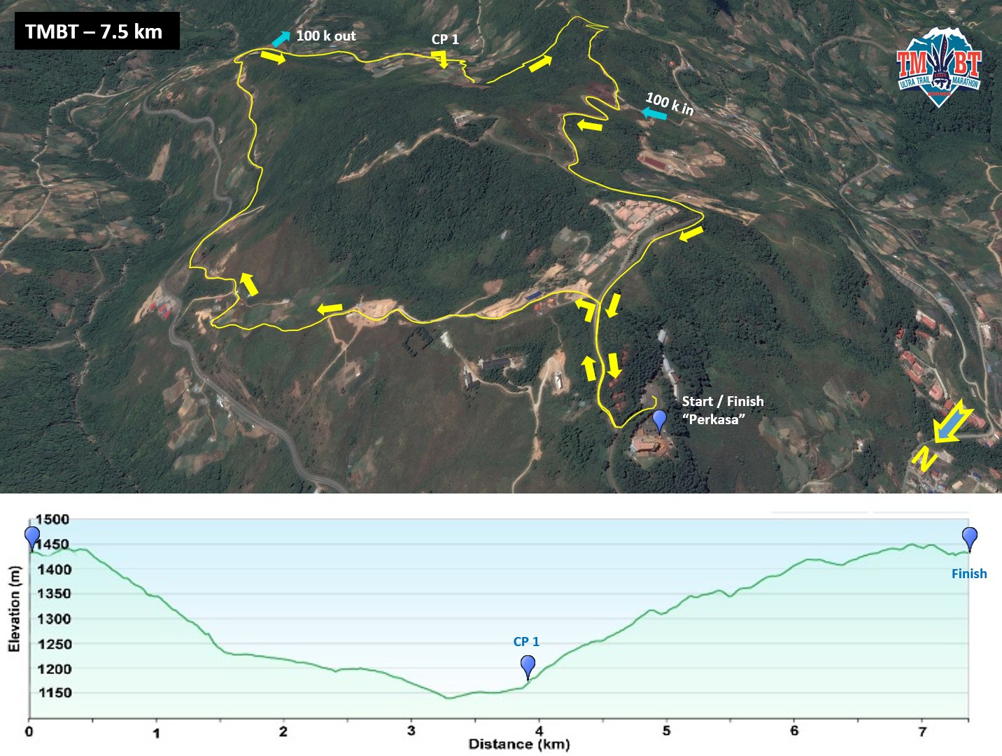
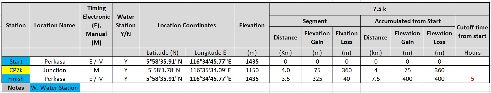
7.5 km Course